
STAY FOCUSED AND SURVIVE
TM

SAR PATHFINDERS


OVERVIEW
Trail Rescue Australia provides specialist SAR Pathfinder support for search and rescue, remote medical and field response operations in difficult, low-support or unfamiliar terrain.
This is a small-team, field-based function focused on finding, confirming and guiding the best way in, through and out of the operational area. It combines advance route reconnaissance, team lead-in, terrain intelligence, key-location verification, extraction-access identification and live pathfinder support to help follow-on teams move faster, safer and with less uncertainty.


SERVICE OPTIONS
Below are sub services with examples and may be offered as a single or modular service that is fused with our other services.
ADVANCED ROUTE RECON
Forward scouting of viable approaches, movement lines and exit routes into, through and out of the operational area. This may include:
foot access reconnaissance
4WD route confirmation
route viability and movement timing
terrain bottlenecks and choke points
vegetation & watercourse constraints
comparison of contingency routes
recommendation for speed, safety & practicality
TERRAIN & ROUTE INTELLIGENCE
Ground-truthed terrain intelligence to support planning, route selection and field decision-making. This is an operational reading of the ground based on how people, vehicles, litters and support elements can actually move through it. This may include:
terrain suitability assessment
access and egress analysis
movement corridor analysis
route hazard identification
track and off-track condition assessment
delay point and mobility analysis
practical route recommendation
FIELD CONFIRMATION OF KEY LOCS
Verification of the locations that matter before resources are committed, redirected or escalated.
This is used where the accuracy of a location directly affects access, search entry, team movement or extraction planning. The purpose is to confirm that critical points are correctly identified, reachable and usable under actual field conditions. This may include:
grid and waypoint confirmation
junction and fork verification
water point and shelter confirmation
crossing and obstacle confirmation
trailhead and access-point checks
search entry-point confirmation
observation or containment locations
LEAD SCOUTING
Lead-scout support to guide SAR teams, medical responders or other follow-on personnel through terrain where navigation, movement efficiency or terrain familiarity is limited. This may include:
lead-in route guidance
approach line selection
terrain trap avoidance
safer movement corridors
low-visibility movement support
guidance to key decision points
route adjustment on the move
EXTRACTION IDENTIFICATION
Identification and confirmation of terrain and infrastructure relevant to extraction, casualty movement and support access. This focuses on where and how responders, vehicles, aircraft or support elements can realistically gain access, hold position and transfer a casualty. This may include:
Extraction route assessment
Stretcher movement assessment
Vehicle access limits
Helicopter landing zone identification
Winch or hover access considerations
Staging and transfer points
Casualty handover locations
PATHFINDER SUPPORT TO SAR OPS
A specialist, low-signature field support element integrated into the broader SAR effort. This supports operations where access, route clarity and terrain understanding are limiting factors, giving incident leads and follow-on teams a clearer picture of how to reach and work within the objective area. This may include:
pre-task route checks
day or night pathfinding
live terrain advice
support to insertion decisions
route refinement during operations
confirmation of approach viability
ground-truth support to incident leads

SERVICE OUTPUTS
Typical outcomes of this service include:
Terrain Intelligence Packages
Night Route Reconnaissance
Landing Zone and Insertion Site Assessments
Extraction Access Briefs
Route Cards and Access Overlays
Search Entry-Point Validation
Staging and Transfer Point Identification
Ground-Truth Mapping Corrections
Movement Timing Estimates
Obstacle and Crossing Assessments
Contingency Route Planning
Live Pathfinder Updates
Air-Ground Access Coordination Support
Remote Access Feasibility Checks
THE ENDSTATE
The objective is not simply to send another person into the field.
The objective is a clearer, safer and more workable access picture for the operation — one that improves movement, reduces delay, supports better deployment decisions and helps follow-on teams reach the right ground with less uncertainty.
In practical terms, SAR Pathfinder support is about making the route to the problem more understood, more usable and more defensible before time and terrain start working against the operation.
If your organisation operates in remote, regional or uncontrolled environments, Trail Rescue Australia can help review, strengthen and refine the systems behind safe field operations.
Contact us to discuss your risk management framework, emergency planning, communications systems or remote travel controls.

FROM THE FIELD
Actual footage and images of rescues, searches, terrain and conditions from the field

Image: Zeroing in on a lost tourist suffering from heat exhaustion in the East Kimberley, WA

Image: Locating a lost hiker in the East MacDonnells Ranges in Central Australia using a UAV.
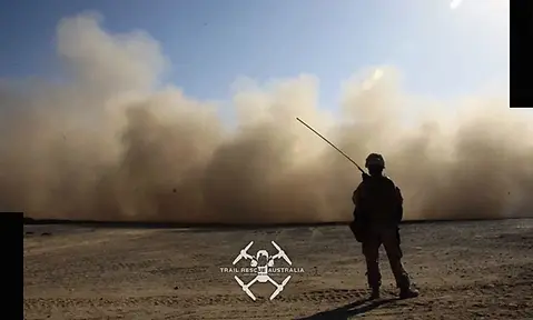
Image: TRA operational systems fuse and synchronise well with Police and Defence.

Image: Using a UAV to cover difficult terrain to locate and identify a broken down 4WD.

